|
|
|
La Esquina Espanola
 |
| Articulo primero escrito por Ken Miller por un periodico. Octubre 30, 1968. |
 |
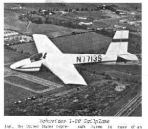 |
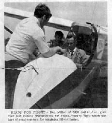
| Ken preparando a volar en un Schweizer 1-33. | Planeador similar a el usado por Ken en su vuelo. |
Ken Miller, Zionite, Wins High Gliding Honors
Following is Miller’s own story of the duration flight which brought him the coveted Silver Badge.
......................................................................
High above Lake Geneva a sailplane circles lazily under a billowing cumulus cloud. Nearly a mile high the small plane is all but invisible to those on the ground below while it rises in the warm air that carried it upward.
In a few minutes the glider will swoop down to land at the Playboy’s Airstrip ending a flight that had begun nearly five and a half hours earlier, 58 miles north in West Bend, Wisconsin. The flight so soon to end will earn for the pilot the coveted Silver C Badge of the Soaring Society of America and climax a summer of soaring.
Preparations for the flight had begun the evening before when a glance at the weather map indicated that a cold front had passed through and a high was developing in the area to set up ideal soaring conditions. This morning a check with the flight service station in Milwaukee confirmed the forecast of the night before. A cold air mass had moved in and a gentle wind was blowing from the Northwest. Cumulus clouds would form at 10 a.m. with bases at 4,500 feet.
A phone call was made to West Bend Flying Service to assure that a sailplane and tow pilot would be available. The word was, “Come on up.” Arrangements were then made for the day off and then a quick trip north to West Bend.
Arriving at West Bend Airport about 10:30 a.m. small cumulus clouds were popping all over the sky. Cumulus clouds mark the tops of the thermals or columns of rising air that keep the sailplane aloft as it flies from place to place.
As quickly as possible a Schweizer 1-26 sailplane is moved out to the field. A barograph, a device to record the altitude and duration of the flight, is sealed by the official observer and placed in the plane. The task today would be an attempt to complete the requirements for the Silver C Badge, an award made by the Soaring Society of America, Inc., the United States representative of Federation Aeronautique Internationale for Soaring, a division of the National Aeronautic Assn.
The requirements consist of three legs: Duration - A flight of at least five hours from time of release. Distance - A flight of at least 31.1 miles. Altitude - A gain in altitude of at least 3,281 feet above the point of release or some low point after release.
The altitude gain had been accomplished the month before at the Schweizer Soaring School in Elmira, N.Y., “the glider capital of America.” At Elmira the 5 hour attempt had ended in failure after 2 hours and 22 minutes. And three cross-country attempts had ended with landings back at the airport. Now with the season coming to a close it was hoped that today would be different.
It was now nearly 11:30 and it was important to get off the ground as soon as possible. High cirrus clouds were moving in from the west and threatening to cut off the sunshine that warms the ground and creates thermals.
The tow plane, a Citabria, was taxied into place in front of the sailplane. A ground crewman connected the 200 foot towline to the tow plane and glider and soon the two planes were climbing above the field. At 500 feet per minute the planes soon reached 2,000 feet and time to release. A quick pull of the red knob on the instrument panel release the tow line with a bang and the sailplane was flying free as the tow plane dove back to the airfield.
Now there was but five minutes to find lift or terminate the flight. Slowly the sailplane descended at 200 feet a minute, gravity pulling it back to the ground: then at 1,800 feet there was a swoosh as the sailplane entered a thermal. The variometer, an instrument which indicates whether the sailplane is rising or sinking, indicated 600 feet per minute up. Now a smooth turn to keep the plane in the rising air.
The horizon whirled past the nose as the sailplane circled in the lift. In just five minutes the plane had gained nearly 3,000 feet and was now flying in the fringes of the cumulus cloud forming at the top of the thermal.
The first goal would be Hartford, 14 miles to the southwest, where an airport offered a safe haven in case of an emergency, although a sailplane can be landed safely in any farm field. With one last backward glance at the west Bend Airport the nose was put down and a glide started toward Hartford, trading altitude for distance.
Slowly the cumulus clouds seemed to come toward the sailplane. From time to time as altitude was lost it was regained by circling in the lift under the clouds. In this way the flight was carried on at an altitude between 4,000 feet and 5,400 feet, more than a mile above the ground. Soon Hartford was below and it was time to head south. Several lakes were lying on the direct line and since they could affect the thermals, a change in course was made a little to the west. A check of the map identified the town ahead as Oconomowoc. Thirty years before the pilot had attended Boy Scout camp there.
Now at 2,400 feet it looked as if he might be paying them an unexpected visit if lift wasn’t found soon. A friendly cloud offered some weak lift and in 20 minutes the plane and pilot were at 4,600 feet and again heading south over the town. It was now over three hours, just two hours to go.
An hour later and low again, but a 20 minute climb in weak lift and the safety of cloud base is reached. A comparison of the chart with the little town below reveals it to be East Troy, 45 miles from West Bend, the distance requirement made. Now, just to stay up for another hour or so to make sure.
The goal, Lake Geneva, is now within easy gliding distance but a large cloud is shading the area and possibly cutting off thermals so it is safer to stay in the lift near Elkhorn and wait for conditions to improve over the goal.
The five hours are up and it’s safe to glide to the goal. The lake sparkles in the sunshine nearly a mile below. Flying beneath the cloud it is no longer even necessary to circle to stay in the lift and the flight could last at least 20 minutes more if there was no lift.
Reluctantly the spoilers are raised and the sailplane circles down to land 5 hours and 32 minutes after releasing at West Bend, the goal reached and the badge won.
Ken Miller
Zion-Benton News
Thursday, October 30, 1969
Otros Photos
 |
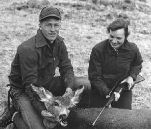 |
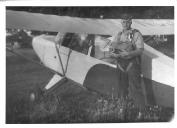
| Ken antes de lanzarse en paracaidas. A los 19 o 20 anos. | Ken y Anne cazando venado en Wyoming cuando estabamos estudiantes en la Universidad de Wyoming en 1953. |
 |
| Ken en Wisconsin con un venado cazado con arco y flecha. 1954. |
Esta Pagina Creada 6 Abril 2004